<<TableOfContents: execution failed [Argument "maxdepth" must be an integer value, not "[2]"] (see also the log)>>
Summary
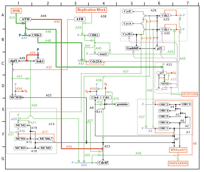
A user wants to reference particular sections of a map
Step-by-Step User Action
- User specifies a map should have a coordinate system
- User species a physical size for the map
- User specifies the number of coordinate system categories
- The system draws axes on the left and top
Visual Aides
The following map includes the coordinate system:

Requirements for Cytoscape
This may not require an underlying model representation, unless there is an effort to annotate the coordinates of features in the map.
Impact on the visualizer, TBD
Importance
This is not a key language constructs of the maps, but is useful for large maps. Coordinates are important to refer readers to particular parts of the map, for example, when the maps are used to illustrate review articles. Smaller maps tend to not have a coordinate system.
Other Examples
Comments
Shared ../MimEditorUseCaseComments
Would not appear to have a BioPAX representation.
AllanKuchinsky - 2006-11-28 04:35:48
Probably best implemented via extensions to CyNetworkView, NetworkViewManager. Coordinates could be stored as attributes of CyNodes, CyEdges, Groups.
Would it be useful to have functionality to zoom in to a particular square on the coordinate system, a la the online Boehringer-Mannheim maps?
MiritAladjem - 2006-12-13 12:55:15
Thank you Allan for the comment.
regarding the second question, yes it will be most useful to add a zoom function to better view details.
AllanKuchinsky - 2007-05-25 12:10:03
Should the labeling of the coordinates update when a pan or zoom of the network occurs?